Standing tall at 5,895 meters (19,341 feet), Mount Kilimanjaro is the crown jewel of Africa and the world’s highest free-standing mountain. Located in Tanzania, near the border with Kenya, Kilimanjaro attracts thousands of climbers each year who are eager to test their limits and revel in its breathtaking beauty. But to conquer this majestic peak, understanding the Kilimanjaro map is essential.
This will definitely range from route selection, identification of campsites, and scenic highlights; this guide gives an overview in detail of all the vital factors that will go a long way to ensure success. A well-detailed map of Kilimanjaro, along with a proper plan, will assist one in the better usage of such a journey-be it for a first-timer or an experienced trekker.
Climbing Mount Kilimanjaro, the highest mountain in Africa, is an adventure on every trekker's bucket list. But the key to a successful and unforgettable experience is having a clear understanding of the Kilimanjaro map.
Kilimanjaro Overview: Mapping Africa’s Tallest Peak
Location: Kilimanjaro is in northern Tanzania, near the border with Kenya. It’s the crown jewel of Kilimanjaro National Park, rising 5,895 meters (19,341 feet) above sea level.
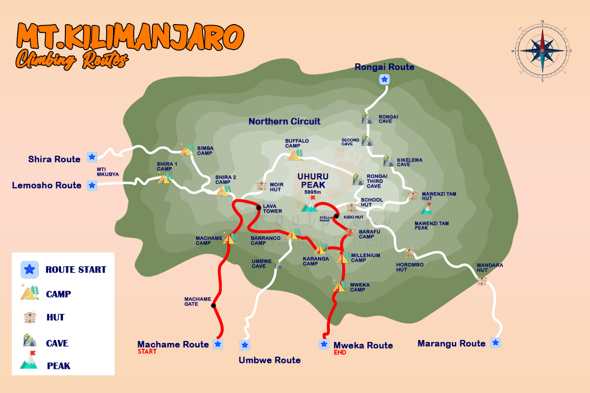
A Kilimanjaro Tanzania map shows how each route approaches the summit, the locations of key campsites, and the breathtaking landmarks you’ll encounter.
A Bird’s-Eye View: The Kilimanjaro Map
Mt. Kilimanjaro is not a mountain but an ecosystem. In the climb, you pass through five different climatic zones from lush rainforests to the icy summit. The Kilimanjaro Tanzania map lays out the major routes, campsites, and scenic landmarks that define this incredible trek.
Each route has its challenges and its rewards. By studying the Kili map, one can make out:
- Starting points and base camps.
- Important campsites on the trails.
- Spectacular views: scenic landmarks such as Lava Tower, Barranco Wall, and many others
- The summit path to Uhuru Peak.
Recommendation Read: A Comprehensive Guidebook for Climbing Kilimanjaro
Routes on the Kilimanjaro Map
There are six main Kilimanjaro routes to the summit, each offering a distinct experience. Here’s an overview to help you decide which one best fits your fitness level, time constraints, and trekking goals.
1. Marangu Route (The “Coca-Cola Route”)

The Marangu Route is the most straightforward and popular choice for beginners. As the only route offering hut accommodations instead of tents, it’s considered more comfortable.
- Duration: 6–8 days.
- Difficulty: Moderate, though the shorter duration may limit acclimatization.
- Key Campsites:
- Mandara Hut: Nestled in the rainforest.
- Horombo Hut: Overlooks the stunning Mawenzi and Kibo peaks.
- Kibo Hut: The final resting point before the summit attempt.
- Scenic Highlights:
- Tropical forests so compact that they are infested with wild creatures.
- Other parts of moorlands with features of giant lobelias and other exclusive plant forms.
- Gradual, straightforward trails leading to Uhuru Peak.
Despite the fact that the Marangu Route is well marked and relatively short, a lower completion rate indicates inadequate time for acclimatization.
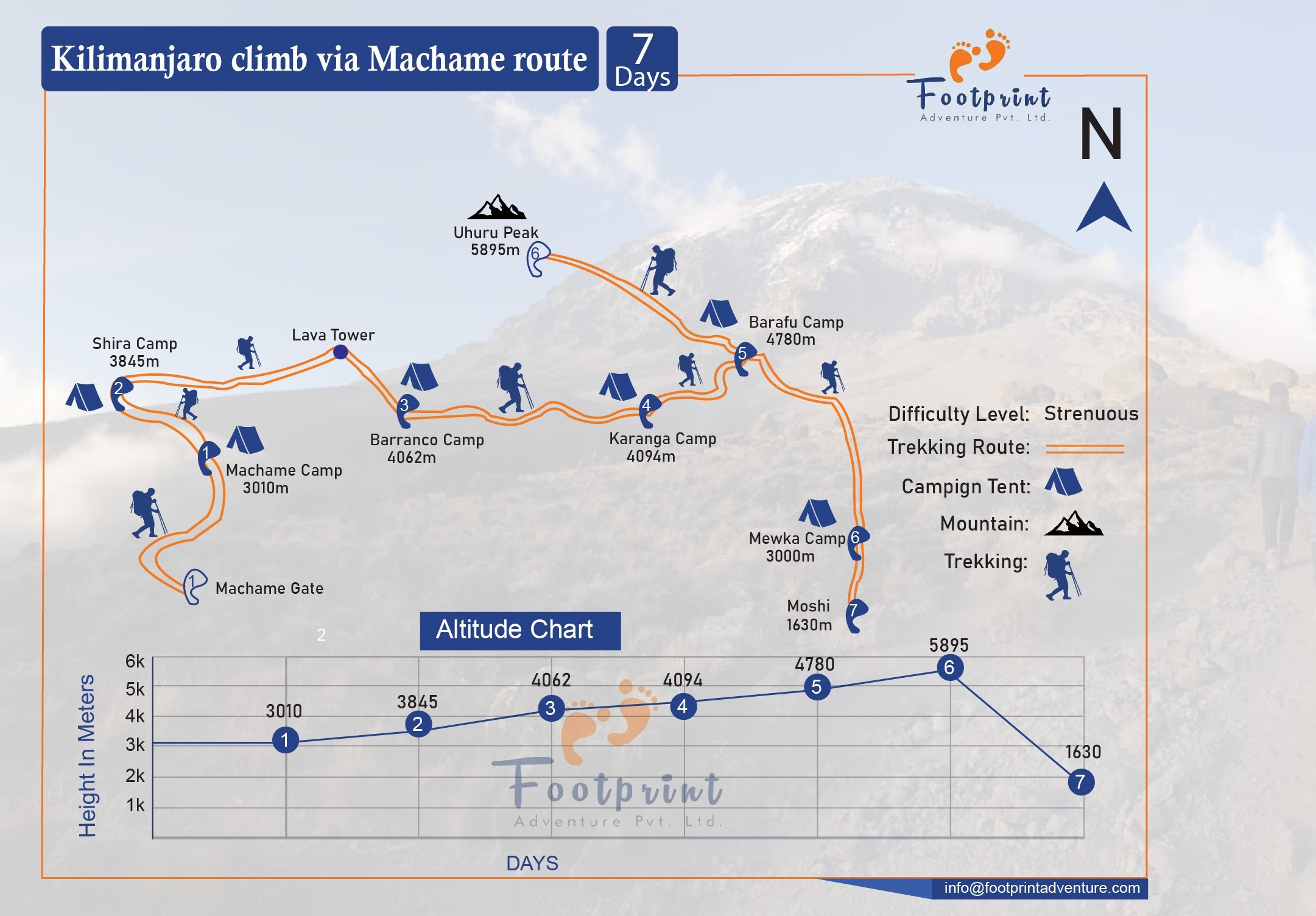
2. Machame Route (The “Whiskey Route”)
Machame route is preferred for experienced climbers and has spectacular views due to the ‘’climb high sleep low’’ strategies because it has high successful rates.
- Duration: 8–9 days.
- Difficulty: Moderate to strenuous, with steep sections.
- Key Campsites:
- Machame Camp: Your first night above the clouds.
- Shira Camp: Located on the expansive Shira Plateau.
- Barranco Camp: Near the iconic Barranco Wall.
- Barafu Camp: The base for summit night.
- Scenic Highlights:
- The impressive Lava Tower, which is primarily used to build up the Mountaineering for the climbers before attempting other areas at high altitudes.
- Enjoying the fantastic sunset from the top of National Geographic’s branded Barranco Wall.
- Outstanding glacier sights when approaching the top.
This path is comparatively difficult but very picturesque and therefore attracts many hikers on the mountain.
3. Lemosho Route
The Lemosho Route is excellent for anyone who would like to have more calm trail with different views and several opportunities of acclimatization.
- Duration: 8–10 days.
- Difficulty: Moderate, with gradual elevation gain.
- Key Campsites:
- Big Tree Camp: Surrounded by lush forests.
- Shira Camps: Offering panoramic views of the plateau.
- Moir Hut: A tranquil stop for acclimatization.
- Scenic Highlights:
- A variety of animals that inhabitants of this land encounter are buffalo and monkeys.
- Fantastic scenery on plateaus of Shira Plateau.
- This habitat ranges from tropical rain forests to high, cold desert country.
Lemosho is a less busy route, and while it is a longer trek, it is a great way to experience Kilimanjaro. For a complete guidebook on Lemosho route, read our blog.
4. Northern Circuit Route
The longest and beautiful route is the Northern Circuit, which goes round the mount’s base particularly on the northern side.
- Duration: 8–10 days.
- Difficulty: Moderate to strenuous.
- Key Campsites:
- Third Cave: A peaceful spot for acclimatization.
- Buffalo Camp: Offering views of Kenya’s plains.
- School Hut: The final camp before the summit.
- Scenic Highlights:
- Some of the new clips show the never before seen northern face of Kilimanjaro.
- Remote and tranquil trails.
- Terrain of plateaus, volcanoes, marine, oasis, desert, tundra, mountain, plateau, and swamp.
Due to its duration, this route offers the very best acclimatization, which makes it very suitable for those who want to have high safety and success rates.
5. Rongai Route
The Rongai Route is unique in that it is the only one of the approaches to Kili from the north, near Kenya.
- Duration: 7–9 days.
- Difficulty: Moderate, with a gentle gradient.
- Key Campsites:
- Simba Camp: Your first campsite, located in the heath zone.
- Kikelewa Camp: Offers stunning views of Mawenzi Peak.
- Mawenzi Tarn: A scenic campsite near an alpine lake.
- Scenic Highlights:
- Views of Kenya’s savannahs.
- Less crowded trails compared to southern routes.
- A steady and gradual ascent.
- The Rongai Route is ideal for trekkers climbing during the rainy season, as it experiences less rainfall.
6. Umbwe Route
The Umbwe Route is the shortest and steepest route, recommended only for experienced climbers.
- Duration: 5–6 days.
- Difficulty: Very strenuous, with little time for acclimatization.
- Key Campsites:
- Umbwe Cave Camp: Nestled in a quiet forest.
- Barranco Camp: The iconic base for climbing the Barranco Wall.
- Barafu Camp: The final stop before the summit.
- Scenic Highlights:
- A direct and dramatic approach to Kilimanjaro’s glaciers.
- Challenging trails with rewarding views.
- The Umbwe Route is best suited for experienced trekkers seeking a fast-paced challenge.
Choosing the Right Kilimanjaro Route
The choice between a route depends on how fit you are, the level of experience in trekking and the amount of time you wish to spend. Slightly longer routes like the Northern Circuit and Lemosho have better success rates because of better acclimatization times. Marangu, the short one will attract hikers who have inadequate time, while Umbwe also short attractive hiker who would like to face steep terrains. For detailed view on Kilimanjaro Climbing Routes, click here.
Best Time To Climb Kilimanjaro(Must Read)
Campsites on the Kilimanjaro Tanzania Map
The campsites on Kilimanjaro are more than just places to rest; they’re essential landmarks for acclimatization and recovery.
- Mandara Hut (Marangu Route): Located in the rainforest zone, surrounded by lush greenery.
- Shira Camps (Machame and Lemosho Routes): Positioned on the scenic Shira Plateau, offering stunning sunsets.
- Barranco Camp (Machame and Lemosho Routes): Near the Barranco Wall, this camp provides one of the most iconic views.
- Barafu Camp (Machame, Lemosho, and Umbwe Routes): A high-altitude base camp for summit pushes.
Each campsite offers its unique atmosphere and serves as a checkpoint on your journey.
Scenic Highlights on the Map of Kilimanjaro
Kilimanjaro isn’t just about reaching the summit; the journey itself is packed with natural wonders:
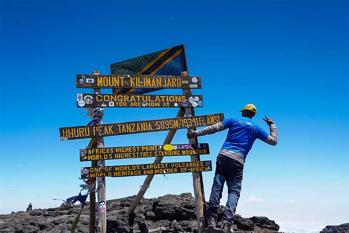
- Uhuru Peak: A view point that allows one to touch the sky and witness the eastern horizon over the Africa continent at sunrise.
- Lava Tower: A towering volcanic formation that doubles as an acclimatization point.
- Barranco Wall: Apparently steep but gives the hiker an amazing view of the surrounding landscapes.
- Shira Plateau: An expansive highland with unique flora and fauna.
- Mawenzi Tarn: A serene alpine lake nestled near Mawenzi Peak.
Tips for Navigating Kilimanjaro
To make the most of your Kilimanjaro map, keep these tips in mind:
- Plan Ahead: There is always a need to find out about a particular route and ensure that you do it in line with the level of your fitness and the time you have.
- Hire a Guide: Local guides and porters provide invaluable expertise and support.
- Pack Smart: Lightweight gear, warm clothing, and a reliable map of Kilimanjaro are essential.
- Acclimatize Properly: Opt for longer routes to minimize altitude sickness risks.
- Stay Hydrated: It suggested frequent intake of water to counter acts of dehydrations at higher altitudes.
Conclusion
For a safe and successful journey, a clear plot map of Kilimanjaro is your weapon of approach.It assists you in planning the numerous and various routes, campsites, and scenic attractions that characterize the Kilimanjaro experience. Whether on the shortest but flattest Marangu Route or the more challenging Northern Circuit, each single step taken on this mountain is part of your story.
Read this guide accordingly, expect the best and the worst, and let the journey of a lifetime starts on the highlands of Kilimanjaro.
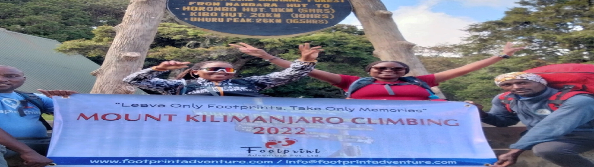
Plan your Treks with Footprint Adventure: Sustainable Practise Travel Company in Nepal. Connect With Us Now.
FAQs
Where is Kilimanjaro in Africa on a map?
Mount Kilimanjaro is located in northern Tanzania, near the border with Kenya, in East Africa. It is part of Kilimanjaro National Park and sits approximately 300 kilometers (190 miles) south of the Equator.
Where is Mount Kilimanjaro on a map?
On a detailed map, Mount Kilimanjaro is situated at 3°04'33'' South, 37°21'12'' East in Tanzania. It’s prominently marked within the Kilimanjaro region, east of the town of Moshi, and is easily identifiable due to its towering height and unique free-standing structure.
Where is Mt. Kilimanjaro on a map?
On a map, Mt. Kilimanjaro can be found in East Africa, in the northeastern part of Tanzania. It’s part of the Great Rift Valley system and stands as the highest peak on the continent.
Where is Kilimanjaro on a map?
Kilimanjaro is prominently displayed in Tanzania, near the border with Kenya, and is a short distance from the Amboseli National Park in Kenya. It’s often included in maps highlighting East African landmarks.
Where is Kilimanjaro on the map?
When viewing a global map, Kilimanjaro is in the southeastern quadrant of Africa, in Tanzania. It is easily recognizable due to its geographical significance and proximity to other notable landmarks like the Serengeti and Ngorongoro Crater.
How tall is Mount Kilimanjaro?
Mount Kilimanjaro stands at 5,895 meters (19,341 feet) above sea level, making it the highest peak in Africa and one of the Seven Summits.
What are the main routes on the Kilimanjaro map?
There are six main routes to the summit of Kilimanjaro:
- Marangu Route
- Machame Route
- Lemosho Route
- Northern Circuit Route
- Rongai Route
- Umbwe Route
Each route offers a unique experience in terms of scenery, duration, and difficulty.
What is the best time to climb Mount Kilimanjaro?
The best time to climb Kilimanjaro is during Tanzania's dry seasons:
- January to March: Cooler weather and fewer crowds.
- June to October: Warm and dry, ideal for trekking.
What are the key campsites marked on the Kilimanjaro map?
The Kilimanjaro map includes key campsites such as:
- Mandara Hut (Marangu Route)
- Shira Camps (Machame & Lemosho Routes)
- Barranco Camp (Machame & Lemosho Routes)
- Barafu Camp (Machame, Lemosho, & Umbwe Routes)
How long does it take to climb Mount Kilimanjaro?
The duration varies by route, typically taking between 5 and 10 days. Longer routes like the Northern Circuit offer better acclimatization and higher success rates.
Is Mount Kilimanjaro a dormant volcano?
Yes, Kilimanjaro is a dormant stratovolcano with three volcanic cones:
- Kibo: The highest and most famous cone.
- Mawenzi: A rugged peak often visible from campsites.
- Shira: The oldest and now eroded cone.
Do I need a guide to climb Mount Kilimanjaro?
Yes, Tanzanian law requires climbers to hire a licensed guide. Trekking agencies typically provide guides, porters, and cooks for a safe and supported journey.
Is altitude sickness common on Kilimanjaro?
Yes, altitude sickness is a common concern due to the rapid ascent. Symptoms can include headaches, nausea, and fatigue. To minimize risks:
- Choose longer routes for acclimatization.
- Stay hydrated and ascend slowly.
What is the success rate of reaching Kilimanjaro’s summit?
Summit success rates vary by route:
- Short routes (e.g., Marangu, Umbwe): ~50–60%.
- Longer routes (e.g., Machame, Lemosho, Northern Circuit): ~85–90%.
Preparation and acclimatization are key to success.
How much does it cost to climb Kilimanjaro?
The cost typically ranges from $1,500 to $5,000, depending on the route, trekking company, and group size. This includes park fees, guide services, and camping arrangements.