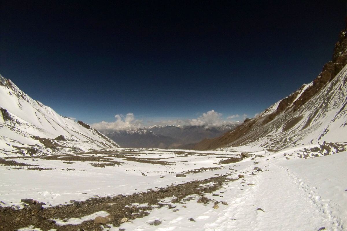
Thorong La Pass sits at 5,416 meters(17,769 ft) above sea level, the highest point on the entire Annapurna Circuit and one of the highest trekking passes in the world. At this altitude, oxygen levels drop to roughly 50% of sea level, and that changes everything about how the crossing feels.
It connects Manang village on the east to the sacred Muktinath Temple on the west. Most trekkers take 8 to 10 hours to cross it. A licensed guide is mandatory, and you need to start around 4:00 AM to beat the winds and safely reach the other side before conditions deteriorate.
This is not a technical climb; no ropes or mountaineering experience is needed. But the altitude, steep ascent, and long descent to Muktinath make it one of the most demanding single days in Himalayan trekking. Crossing Thorong La Pass is not just a trek; it is a test of patience, preparation, and respect for the mountain.
What is Thorong La Pass?
Thorong La Pass is one of the most famous high-altitude trekking passes in the world. It sits inside the Annapurna Conservation Area in central Nepal, along the legendary Annapurna Circuit route. The pass links the Manang Valley on the east with the Mustang region on the west. Historically, it was used as a trade route between these two very different landscapes, one green and vibrant and the other dry and arid like a high-altitude desert.
Today, it is the highlight of the Annapurna Circuit trek. Most trekkers plan their entire itinerary around crossing it. It is not a technical climb. No ropes, no ice axes. But the altitude, distance, and effort make it genuinely strenuous. One thing that surprises people: at 5,416 meters, Thorong La Pass is actually 52 meters higher than Everest Base Camp (5,364 m). You are reaching extreme altitude without any technical mountaineering. That alone tells you what kind of challenge this is.
Why Is Thorong La Pass the Major Highlight of the Annapurna Circuit?
Crossing Thorong La Pass isn’t just another high-altitude trek. It’s the kind of climb that tests your legs, lungs, and patience but rewards you with views and experiences you won’t forget. From extreme elevation to dramatic landscape changes and spiritual landmarks, it’s the heart of the Annapurna Circuit.
The Geographical Apex: Higher than Everest Base Camp (5,364m)
Yeah, you read that right. At 5,416 meters, Thorong La Pass is actually 52 meters higher than Everest Base Camp. Most people don't realize this, but you're reaching extreme altitude without needing any technical climbing skills. The pass touches the edge of the Tibetan Plateau. You're literally standing on the threshold between two massive geographic zones.
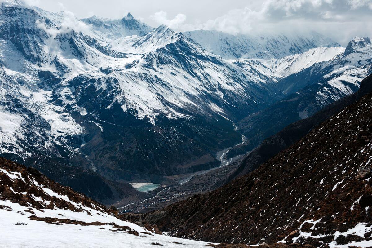
The "Two-World" Shift: From Marsyangdi valley to arid Mustang landscape
This is what gets people. The landscape transformation is borderline surreal. You spend days hiking through the Marsyangdi Valley, green forests, terraced fields, and rhododendron blooms in the spring. Then you cross Thorong La Pass, and suddenly you're in a completely different climate zone.
The Mustang side is dry, windy, and barren. It looks like you've been teleported to Tibet. Basically, you have the rain shadow side of the Himalayas. The Annapurna massif blocks all the monsoon moisture, creating this high-altitude desert.
Spiritual Milestone: Summit prayer flags and descent to 108 waterspouts of Muktinath
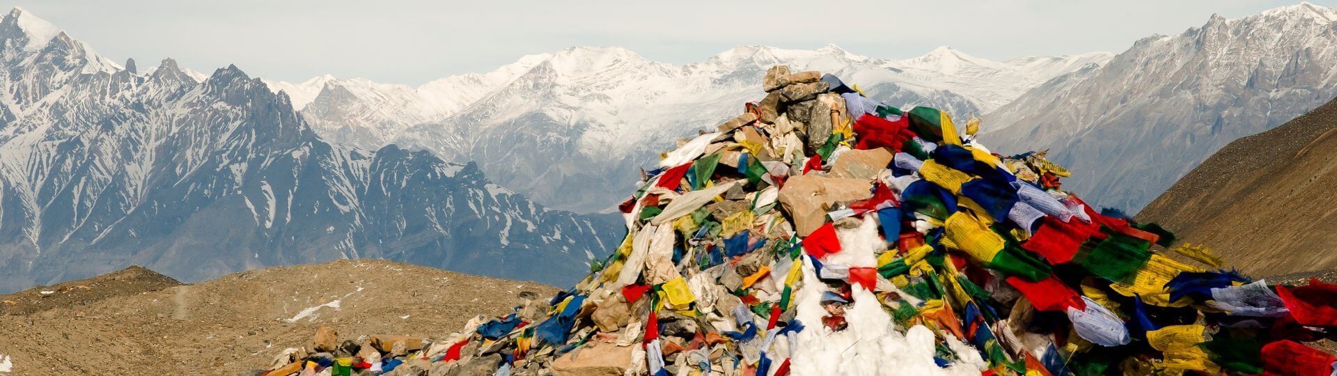
The summit itself is marked by thousands of prayer flags snapping in the wind. There's a chorten (Buddhist shrine) and usually a crowd of exhausted, elated trekkers taking photos.
But the spiritual payoff comes when you descend to Muktinath. This sacred site has 108 water spouts (representing the 108 desires in Buddhism) and is holy to both Hindus and Buddhists. After the brutal past day, reaching Muktinath feels like arriving at an oasis.
Thorong La Pass: Altitude, Height & Oxygen Reality
Thorong La Pass is not just physically demanding because of the steep trail. The altitude itself is the challenge. At this height, your body is working in conditions it was never designed for, and that changes everything about how the crossing feels.
Altitude & Height
Thorong La Pass sits at 5,416 meters (17,769 feet) above sea level. That makes it one of the highest trekking passes in the world and 52 meters higher than Everest Base Camp (5,364 m).
To put that in perspective, you are standing higher than most people ever reach without technical mountaineering gear. The elevation gain on crossing day alone is nearly 1,000 meters from Thorong Phedi, a serious climb at any altitude, let alone at 5,416 meters.
Warning Signs to Watch
Headache, nausea, or dizziness on the way up means altitude sickness. Do not push through it. Rest, drink water, and if symptoms worsen, descend. No summit is worth the risk.
Is the Thorong La Pass Difficult?
Honestly? Yes. But probably not in the way you are imagining. Most people expect the difficulty to come from the climbing itself, the steep sections, the rocky trail, and the altitude gain. And those things are hard.
But the real difficulty of the Thorong La Pass is cumulative. It is 10 hours of effort stacked on top of a bad night's sleep at 4,500 meters, on a body that is running on half the oxygen it normally gets. That is what breaks people. Not one brutal section. The whole day.
The Physical Reality
Thorong La Pass difficulty for beginners is not about technical skill. You do not need ropes, harnesses, or ice axes. What you need is endurance, the kind that comes from weeks of consistent training before you arrive.
The crossing day covers roughly 15 kilometers from Phedi to Muktinath. On flat ground at sea level, that is a comfortable morning walk. At altitude, with 966 meters of climbing followed by a 1,600-meter descent, it is a full-day physical event. Your heart rate runs higher than normal just standing still. Every step up requires conscious effort.
The terrain does not help either. Rocky, sometimes icy, always uneven. Your ankles work overtime the entire day.
What 50% Oxygen Actually Feels Like
At 5,416m, the air holds roughly 50% of the oxygen available at sea level. Your heart beats faster just standing still. Your lungs work twice as hard to do the same job. Even experienced trekkers feel it immediately. This is hypoxia. It is the main reason Thorong La Pass is rated strenuous: not just the steep terrain, but your body operating at half capacity the entire day.
This is what catches even fit trekkers off guard. Altitude sickness is not a fitness problem; it is a blood chemistry problem. Your body needs time to produce more red blood cells to carry oxygen efficiently at this elevation. No amount of gym training speeds that process up. A marathon runner with poor acclimatization will suffer more than a moderately fit trekker who spent three nights in Manang.
AMS, acute mountain sickness, shows up as headache, nausea, loss of appetite, and a bone-deep fatigue that sleep does not fix. If those symptoms appear on the way up, slow down. If they get worse, turn around.
The Descent Nobody Talks About
Here is the part most guides skip over: the climb up is not the hardest part of the day. From the summit, you drop 1,600 meters to Muktinath in roughly 3 to 4 hours. Loose scree, exposed sections, and patches of black ice in the early morning. Your legs are already spent from the ascent. Now you are asking your quads to act as brakes on a steep, slippery slope for four straight hours.
Most crossing-day injuries happen on this descent. Twisted ankles, blown knees, bad falls. Not on the dramatic climb up, but on the way down when people are tired and guards are down. Trekking poles are not optional gear. Bring them. Use them from the summit all the way to Muktinath. Your knees at 50 years old will be grateful you did.
Thorong La Pass Trek Route (Complete Breakdown)
The Thorong La Pass trek route is straightforward but demands careful planning. It is not just about walking; it is about pacing yourself across multiple days, gaining altitude gradually, and timing your crossing day right. Here is exactly how the route breaks down.
The Full Annapurna Circuit Route
The Annapurna Circuit follows one main path. Here is the classic route from start to finish:
Besisahar → Chame → Pisang → Manang → Yak Kharka → Thorong Phedi → High Camp → Thorong La Pass (5,416m) → Muktinath → Jomsom → Pokhara
Most trekkers finish the full circuit in 12 to 18 days. The exact number depends on how many acclimatization days you take and how fast you walk.
The Pass Day Route
On crossing day, you move through four main points:
Thorong Phedi (4,450m) → High Camp (4,880m) → Summit (5,416m) → Muktinath (3,760m)
Here is how long each section takes:
- Phedi to High Camp: 1 to 1.5 hours. Short but steep. Think of it as the warm-up.
- High Camp to Summit: 4 to 5 hours. This is the hardest part. Slow, breathless, and relentless.
- Summit to Muktinath: 3 to 4 hours. A long descent on loose rock. Your knees will feel every step.
- Total crossing time: roughly 8 to 10 hours.
Planning to cross Thorong La Pass? Don’t go unprepared. Contact Footprint Adventure to prepare your Thorong La Pass adventure.
When is the Best Time to Cross Thorong La Pass?
The best time to cross Thorong La Pass is spring (March–May) for blooming rhododendrons and lingering snow, or autumn (September–November) for clear skies and stunning mountain views. Avoid winter and monsoon due to extreme weather risks.
- Spring (March–May): This is when rhododendrons bloom at lower elevations; the hillsides explode in red and pink. Beautiful, but there's a catch: lingering snow. March can still have significant snow on the pass. Microspikes (lightweight crampons) are highly recommended. April and early May are the sweet spot for warmer temps and mostly clear trails.
- Autumn (September–November): The gold standard season. Post-monsoon clarity means crystal-clear mountain views. Temperatures are cold but manageable. October is peak season, which means crowded trails and fully booked teahouses.
- Winter & Monsoon Warning: December–February is technically possible but extremely cold. Temperatures at the pass can hit -25°C or lower. Only for hardcore winter trekkers.
- Monsoon (June–August) is a hard no. Not just because of rain, but because of leeches at lower elevations and the risk of landslides. Plus, cloud cover kills the views.
Thorong La Pass Weather & Temperature
The weather on Thorong La Pass is cold, windy, and unpredictable at any time of year. There is no such thing as a guaranteed good day on this pass. Even in the best trekking months, conditions can shift within an hour. Understanding what to expect and what can go wrong is part of preparing properly.
- Summit temperature: Ranges from -10°C to -20°C in the early morning during peak seasons. With wind chill, it feels significantly colder. In winter months, temperatures can drop below -25°C, making a crossing genuinely life-threatening without proper gear.
- Afternoon winds: Thorong La Pass sits in a natural wind tunnel between Khatung Kang and Yakawa Kang peaks. Winds pick up fast after 10:00 AM. This is why the 4:00 AM start is not just tradition; it is a safety rule.
- Snow: Can fall any time of year, even in October and May. Never assume clear weather just because you are trekking in peak season. Fresh snow makes the trail icy and significantly increases the risk of slipping, especially on the descent to Muktinath.
- Morning vs. afternoon: The pass behaves like two completely different places depending on the time of day. Early morning is cold but calm and manageable. By midday, wind speeds can make standing upright genuinely difficult. This is not an exaggeration; trekkers who start late regularly turn back because of wind alone, not altitude.
A reminder of what mountain weather can do: in October 2014, Cyclone Hudhud dropped 1.8 meters of snow on Thorong La Pass in just 12 hours during what should have been a safe trekking season. 43 people lost their lives.
Mountain weather does not care about calendars. If your guide or local teahouse owner says to wait a day, wait. Local knowledge always beats your schedule.
Thorong La Pass Weather Forecast Today
Before you attempt the crossing, check the weather, and not on a standard app. Google Weather and AccuWeather are not accurate at 5,416 meters. You need mountain-specific tools.
Best sources to check:
- Mountain Forecast (mountain-forecast.com): Most reliable for high-altitude weather. Search "Thorong La Pass" and check wind, temperature, and precipitation by elevation.
- Windy (windy.com): Best for visualizing wind patterns on crossing day.
- Your guide and teahouse owners: Still the most accurate source. Many teahouses at High Camp now have Starlink and check forecasts every evening.
Check the forecast the evening before, not the morning of. By 3:30 AM, it is too late to make a good decision. If the weather looks bad at 8:00 PM, talk to your guide then and decide together. Mountain weather shifts fast. A clear forecast is not a guarantee, but checking the right sources gives you the best chance of making a smart call.
Thorong La Pass Direction: Why East to West is Better
Most trekkers cross from east to west, Manang to Muktinath, and there is a solid reason for it. The Annapurna Circuit is designed for this direction. By the time you reach Manang, you have already spent several days gradually gaining altitude. You acclimatize there, then push to Phedi and High Camp. The ascent feels hard but manageable because your body has had time to adjust.
Going west to east flips all of that. You would be climbing 1,600 meters from Muktinath to the summit without that gradual build-up. The acclimatization profile simply does not work in reverse. East to west is safer, better for your body, and the strongly recommended direction.
Thorong Phedi vs. High Camp: Where Should You Stay?
This is one of the most common questions trekkers ask before crossing day, and the answer depends on how your body handles altitude. Both options have real advantages and real tradeoffs. Here is an honest breakdown of each so you can make the right call for yourself.
- Thorong Phedi (4,450m): Better for sleep quality. At 4,450m, you're less likely to suffer from severe altitude symptoms. More teahouse options, which means a better chance of getting a room during peak season. Lower risk of Cheyne-Stokes breathing keeps you awake.
- High Camp (4,880m): Shorter ascent on pass day. You're already at 4,880m, so you "only" need to climb 536 vertical meters to the summit. Means you can start a bit later, around 5:00 AM instead of 4:30 AM.
Pro Tip: If this is your first night above 4,800m, stay at Phedi. Better sleep means better performance on the past day. The extra climbing time is worth it.
Infrastructure & Facilities on the Route
Do not expect comfort on this section of the trek. The infrastructure between Thorong Phedi and Muktinath is basic by design. Here is what you will find at each stop so there are no surprises.
Thorong Phedi (4,450m)
Basic private and dormitory rooms with shared bathrooms. Heating is minimal, so bring a sleeping bag liner. Food is simple dal bhat, noodles, soups, and eggs but adequate. Prices are higher on the circuit because everything is carried up by mule. Charging points are available in the dining area. Charge everything here because options get worse higher up.
High Camp (4,880m)
Fewer teahouses than Phedi, and it fills up fast in peak season. Arrive early to secure a room. Room quality is slightly lower, nights are colder, and sleep is harder at 4,880m. Food options are similar to Phedi but pricier. Several teahouses now have Starlink satellite internet, which lets your guide check real-time weather the evening before your crossing. Use it. Charge your headlamp and camera before you sleep.
At the Summit (5,416m)
No permanent structures. No shelter. No teahouse. If conditions deteriorate while you are at the top, your only option is to descend immediately. Another reason why the early start is non-negotiable.
Muktinath (3,760m)
A complete contrast to everything above. Proper hotels, full restaurants, ATMs, and reliable mobile signal. After 9–10 hours of crossing, it feels like a different world, which, honestly, it is.
Thorong La Pass Logistics: Permits, Guides, and Road Updates
You need two permits to trek Thorong La Pass: ACAP (3,000 NPR) and TIMS (2,000 NPR). These can be obtained in Kathmandu or Pokhara, and processing is quick if you have your passport, photos, and cash.
Solo trekking isn’t allowed; you must hire a licensed guide from a registered trekking agency. Guides handle logistics, know the best teahouses, and watch for altitude sickness, making them worth every penny.
To avoid dusty jeep roads, many trekkers take the NATT trail, a quieter, greener alternative. Some teahouses at Thorong Phedi and High Camp have Starlink, but mobile signal is limited past Manang, and there’s none at the pass.
Don’t stress about permits or finding a licensed guide. Let Footprint Adventure handle everything so you can focus on the mountains. Book your trek today.
Challenges and Risks at Thorong La Pass: What Every Trekker Must Respect
Crossing Thorong La Pass isn't a technical climb, but it's absolutely a high-altitude endurance event. Preparation isn't just recommended; it's critical.
1. The Invisible Threat: Altitude Sickness (AMS, HAPE, HACE)
At 5,416 meters, you're in the danger zone. Oxygen at the summit is only ~50% of sea level. Even incredibly fit trekkers can suffer because altitude sickness isn't about fitness; it's about how your blood adapts to low oxygen
The real danger zones are Thorong Phedi (4,450m) and High Camp (4,880m). You're sleeping at these altitudes the night before your crossing, which means your body is already stressed before you even start.
Warning signs to watch for:
- Headache that won't go away, even with water and ibuprofen
- Complete loss of appetite (not just "I'm tired of dal bhat" but genuine nausea)
- The infamous Khumbu Cough is a rattling, hacking cough that won't stop
- Feeling drunk or dizzy when you're stone-cold sober
The red line is loss of coordination. If you can't walk a straight line, if you're stumbling over nothing, that's HACE (High Altitude Cerebral Edema). You need to descend immediately. Not tomorrow. Not in an hour. Now.
HAPE (High Altitude Pulmonary Edema) is equally dangerous as fluid in your lungs. You'll feel like you're drowning on dry land. Gurgling sounds when you breathe. Descend immediately.
2. The "Wind Tunnel" & Harsh Weather Extremes
Thorong La Pass sits in a natural wind tunnel between Khatung Kang and Yakawa Kang peaks. The geography funnels wind straight through the pass. There's this unspoken rule: the 10:00 AM cutoff. After 10 AM, winds pick up dramatically. Wind chill can drop temperatures to -20°C (-4°F) or worse. What feels manageable at dawn becomes genuinely dangerous by mid-morning.
This is why everyone starts hiking at 4:00 AM. You're not just racing daylight; you're racing the wind. Snow blindness is a real risk. The sun at 5,400 meters is intense, and when it reflects off snow, it can literally burn your corneas. Category 4 glacier goggles are essential, not optional.
3. The 2014 Legacy: Unpredictable Storms
“Remember Cyclone Hudhud in October 2014? It struck during peak trekking season. The Himalayas don’t follow a fixed pattern; clear skies can turn into storms overnight. That’s why it’s always wise to keep a few extra days in your plan.”
In just 12 hours, 1.8 meters of snow fell on Thorong La Pass. Forty-three people lost their lives: trekkers, guides, and locals. Some froze to death. Others were buried in avalanches. The storm came during what's supposed to be the "safe season." The lesson? Peak trekking season does not equal safe season. Mountain weather is fundamentally unpredictable.
Updates: Things have improved. Many lodges now have Starlink satellite internet. Weather forecasting is better. There's real-time tracking of wind patterns. But the mountains don't care about technology.
If your guide in Manang says, "We're waiting another day," you wait. Period. Local knowledge beats your trekking schedule every single time.
4. Physical & Mental Exhaustion (The "Big Day" Burnout)
The day is long. Really long. You start at 4:00 AM in the freezing dark. You climb for 5-6 hours. Your body is running on fumes because you couldn't sleep well at 4,500 meters. You reach the summit. And then, and this is the killer, you still have that 1,600m descent.
Loose scree on the western side makes every step unstable. Early in the morning, patches of black ice add another layer of risk. Your legs feel weak after hours of climbing, and your mind gets cloudy from the altitude. This is exactly when mistakes happen when you’re tired, unfocused, and just trying to get down as quickly as possible.
The mental side is sneaky. You'll hit false summits thinking you're almost there, only to realize you've got another hour of climbing. It's demoralizing. You start questioning why you even attempted this. Energy drain at 5,000m is exponential. Every step takes conscious effort. Your body is screaming for oxygen that isn't there.
5. Navigation & Trail Risks (Mandatory Guide Rule)
A licensed guide is mandatory for Thorong La Pass. This isn't the government being bureaucratic; it's a safety measure that actually makes sense. Guides prevent people from getting lost in whiteout conditions. They know which sections are avalanche-prone. They have GPS, internal maps downloaded offline, and most importantly, local knowledge.
In good weather, the trail is obvious. But the weather changes fast. Clouds roll in. Visibility drops to ten meters. Suddenly, you're guessing where the trail goes. This is how people die. Plus, if you get AMS, you're not thinking clearly. You might insist you're fine when you're objectively not. A good guide will recognize symptoms before you do.
Crossing Thorong La Pass: Step-by-Step Guide for the Big Day
Here is exactly what the crossing day looks like, hour by hour.
- 3:00–3:30 AM: Wake up, eat breakfast if you can stomach it. At altitude, appetite often disappears. Force something down; you will need the energy.
- 4:00 AM: Start hiking. The air is cold, and it’s still pitch dark. Bring a headlamp and dress in full layers. The early start is essential for two reasons: you need time to complete the full crossing before afternoon winds arrive, and the trail is more manageable in the cold morning air.
- 4:00–9:00 AM: The long climb to the summit. Switchbacks, steep sections, rocky terrain. Your pace will be slow. That is normal. Rest every 20 - 30 steps if needed. Keep drinking water. Do not rush.
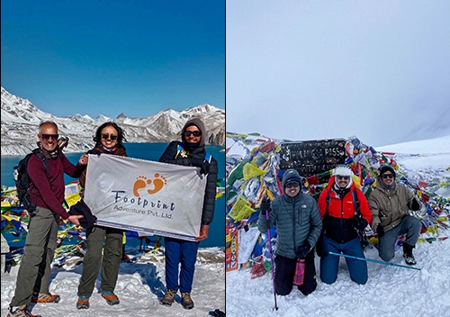
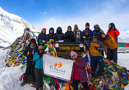
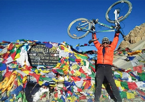
- 9:00–10:00 AM: Summit at 5,416 meters. Prayer flags everywhere. A Buddhist chorten. Trekkers taking photos, some crying with relief. Take time to celebrate, but do not stay too long; the wind picks up significantly after 10 AM.
- 10:00 AM–1:00 PM: The descent to Muktinath, 1,600 meters down through loose scree and rocky trails. This section destroys your knees if you do not use trekking poles. Go slow. Controlled steps. Your legs are already exhausted.
- 1:00–2:00 PM: Arrival in Muktinath, celebration & recovery: The descent feels endless. Your knees are screaming. Your toes are jammed into the front of your boots.
But reaching Muktinath brings a quiet sense of relief. The hardest part is behind you. You’ve crossed one of the highest trekking passes in the world, step by step, breath by breath. Take time to rest, rehydrate, and let your body recover. What felt impossible in the morning is now an achievement you’ll carry for life.
Attractions Along the Thorong La Pass Route
The journey to the pass is as good as the pass itself. Here are the main attractions you should not miss:
- Manang Village (3,540m): A beautiful, traditional Tibetan-influenced village. Your main acclimatization stop. Spend at least two nights here.
- Ice Lake / Kicho Tal (4,600m): An optional day hike from Manang. A stunning turquoise alpine lake. This hike helps your body acclimatize before the pass.
- Gangapurna Lake: Glacial lake near Manang with mirror reflections of the peak. Perfect for afternoon walks during acclimatization days.
- HRA Altitude Lecture: Free, informative presentations by the Himalayan Rescue Association in Manang. Attend this. Seriously.
- Yak Kharka (4,050m): A small settlement on the way to Phedi. Good lunch stop or overnight option.
- Thorong Phedi (4,450m): Last stop before the final climb. Basic teahouses, cold nights, and a sense of anticipation.
- High Camp (4,880m): The staging point for most crossings. Incredible views at sunset if the sky is clear.
- Thorong La Summit (5,416 m): Prayer flags, a chorten, and panoramic views of Khatung Kang, Yakawa Kang, and, on clear days, Dhaulagiri (8,167 m).
- Muktinath Temple (3,760m): Sacred Hindu and Buddhist pilgrimage site. 108 water spouts. Natural gas flames. An extraordinary place to end your crossing day.
Want to experience all these highlights yourself? Footprint Adventure can handle everything from experienced guides to comfortable teahouses and a well-planned Annapurna Circuit itinerary. Start planning your trek today.
Essential Gear for Thorong La Pass
Packing right makes the difference between a hard but manageable crossing and a genuinely dangerous one.
Best Micro-Spikes for Thorong La Pass
In snowy conditions, especially crossing Thorong La Pass in March snow, micro-spikes can be essential. The trail can get icy and slippery, particularly on the early morning sections and on the descent.
Recommended options:
- Kahtoola MICROspikes: The gold standard. Lightweight, easy to put on, and grip well on ice and packed snow.
- Yaktrax Pro: Good for moderate icy conditions, slightly less aggressive than Kahtoola.
- Hillsound Trail Crampon Ultra: More aggressive grip, good for steeper icy terrain.
You may not need them every crossing. But if there has been recent snow, you will be glad you have them.
Cold-Weather Gear
- Insulated down jacket: Minimum 600-fill. You need this at High Camp and on the summit.
- Waterproof outer shell: Wind and snow protection. Essential.
- Liner gloves + insulated mittens: Layered hand protection. The summit is brutally cold.
- Thermal base layers: Merino wool is best. Synthetic works too.
- Warm hat and balaclava: Cover your ears and face on the summit.
- Trekking poles: Mandatory for the descent. Your knees will thank you endlessly.
- Category 4 glacier goggles or UV sunglasses: Snow blindness is a real risk. The sun at 5,400m is intense.
- Headlamp with spare batteries: You are starting at 4 AM in complete darkness.
- High-energy snacks: chocolate, nuts, energy bars. Appetite drops at altitude, but you still need fuel.
Thorong La Pass vs. Cho La Pass: Which is Harder?
Cho La Pass is generally harder than Thorong La Pass. Cho La has a glaciated section with some technical terrain, while Thorong La Pass is longer but fully non-technical. Here is a side-by-side comparison:
| Feature | Thorong La Pass | Cho La Pass |
|---|
| Altitude | 5,416 m | 5,420 m |
| Location | Annapurn Circuit | Everest Region |
| Technical Difficulty | Non-technical | Slightly technical |
| Day Duration | 8 - 10 hours | 5 - 7 hours |
| Scenery | Himalayan panorama & Mustang desert | Everest region glaciers |
| Overall Difficulty | Strenuous | Strenuous+ |
| Best For | First major pass experience | Trekkers with some alpine experience |
Cho La is shorter but involves a glaciated section that can require crampons. Thorong La Pass is longer, at a slightly lower altitude, and fully non-technical. For first-time high-altitude pass crossings, Thorong La Pass is the more approachable choice. But both are serious undertakings that require proper preparation.
Success Rate of Crossing Thorong La Pass
The success rate of crossing Thorong La Pass is actually quite high but only among trekkers who prepare properly. Most estimates suggest that 85–90% of trekkers who arrive at Thorong Phedi in good health make a successful crossing. The 10–15% who turn back almost always do so for the same handful of reasons.
- Poor acclimatization: Rushing the circuit without spending enough time in Manang. This is the most common reason by far.
- Sudden bad weather: A storm rolls in, and the pass becomes impassable. This is out of your control, which is why flexibility in your schedule matters.
- Altitude sickness symptoms: Trekkers who developed serious AMS signs and made the responsible decision to descend instead of pushing through.
- Starting too late: People who left Phedi or High Camp after 5–6 AM and ran into strong afternoon winds.
The lesson: success is mostly in your hands. Acclimatize properly. Start early. Choose the right season. Listen to your guide.
Safety Tips for Crossing Thorong La Pass
Thorong La Pass is manageable but only if you respect it. Most things that go wrong on this crossing come down to poor timing, ignored symptoms, or overconfidence. Follow these tips, and you give yourself the best possible chance of a safe, successful crossing.
- Start at 4:00 AM, not 5:00 AM. The wind is your main enemy, and it arrives reliably after 10 AM.
- Follow the trail markers. In snow or low visibility, it is easy to veer off the route. Your guide is essential here.
- Trek with a licensed guide. Required by law and genuinely life-saving in poor conditions.
- Tell someone your plan. Sign the logbook at checkpoints. Your guide should register you.
- Turn back if symptoms get serious. Summit fever kills people. A functioning body can attempt Thorong La Pass another day.
- Stay together as a group. Do not let anyone fall behind without checking on them.
- Carry a basic first aid kit. Include ibuprofen, altitude medication if prescribed, blister care, and an emergency thermal blanket.
Prepare well and start early; those two things alone will take you further than any gear or fitness level. The rest is just common sense and listening to your guide.
Final Thoughts
Thorong La Pass is not easy. Your legs will feel heavy, your breathing will be slow, and that early morning start will test your will. But standing at 5,416 meters, surrounded by endless peaks and fluttering prayer flags, is something few experiences can match. Even with better trails, roads, and WiFi in some places, the mountain still demands respect. This is not just a physical journey; it’s a mental and emotional one too. You cross more than a pass; you cross into a completely different landscape and mindset.
With the right preparation, proper acclimatization, and smart decisions, most trekkers make it across safely. And when you finally reach Muktinath Temple, tired but proud, it all makes sense. This is more than a trek; it’s a memory that stays with you long after you leave the mountains.
Feeling ready for Thorong La Pass? Start your adventure safely and comfortably with Footprint Adventure. Contact us today to plan your trek.
Frequently Asked Questions
Can beginners cross Thorong La Pass?
Yes, but only with proper preparation. You should train 2–3 months in advance with cardio, leg workouts, and practice hikes. If you’re new, it’s smart to try lower-altitude treks first.
Is there mobile signal at the top?
No. Network coverage usually ends before Thorong Phedi. Some lodges offer WiFi (often via Starlink), but on the pass itself, you’ll be completely offline.
Do I need a horse to cross the pass?
No. Horses and mules are used for carrying goods, not trekkers. The trail is steep and narrow, so you’ll need to walk the entire way.
How cold does it get at 5,416m?
Temperatures on crossing mornings usually range from -10°C to -20°C, and it feels colder with wind chill. In winter, it can drop below -25°C, so proper layering is essential.
Can I trek without a guide?
No. A licensed guide is now required for the Annapurna Circuit, and this rule is checked at multiple points.
Which direction is better?
Always go east to west (Manang → Muktinath). This route allows proper acclimatization. Going the opposite way increases altitude too quickly and is risky.
Is Diamox necessary?
Not required, but helpful. Diamox can reduce the risk of altitude sickness. Talk to your doctor before using it. A common dose is 125 mg twice a day.
How many days are there from Manang to the pass?
Plan 3 - 4 days: Manang → Yak Kharka (1 day) → Thorong Phedi (1 day) → optional rest or move to High Camp → summit day. Rushing this section increases altitude sickness risk.
What is the NATT trail?
The Nepal Alternative Trekking Trail (NATT) avoids jeep roads and follows a quieter, more scenic path between Jagat and Chame. It’s a better trekking experience; ask your guide to follow it.